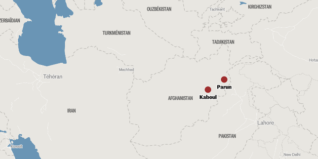
The human and economic toll of sudden-onset hydrological disasters is rarely a function of rainfall volume alone. When flash floods strike highly vulnerable regions—as seen in recent compounding disasters in Afghanistan resulting in dozens of confirmed fatalities and over a hundred missing individuals—the outcome is determined by a predictable intersection of severe weather, degraded topography, and non-existent infrastructure. Understanding these events requires moving past basic casualty counts and analyzing the specific mechanics of environmental vulnerability and the logistical bottlenecks that paralyze search and recovery operations.
The Hydrological Shock Transmitted to Degraded Basins
Flash flooding in arid and semi-arid mountainous regions follows a distinct physical process. The structural failure of a landscape to absorb water can be broken down into three primary variables: For an alternative perspective, see: this related article.
- Soil Hydrophobicity and Compaction: Prolonged dry spells bake topsoil into an impermeable layer. When intense, short-duration rainfall hits this surface, infiltration rates drop to near zero. Instead of saturating the ground, the water immediately converts into Hortonian overland flow.
- Topographic Amplification: Steep terrain accelerates runoff. Water collects rapidly in narrow valleys and dry riverbeds (wadis), transforming a localized rain event into a high-velocity torrent capable of moving boulders, vehicles, and structural foundations.
- Deforestation and Loss of Vegetative Friction: The systemic removal of root systems eliminates the natural barriers that slow down surface water. Without vegetative friction, the time to peak hydrograph—the window between the start of rainfall and the maximum flood height—is drastically shortened, rendering early warning systems functionally useless.
This combination shifts the disaster from a weather event to a structural failure of the geography. The resulting torrents carry massive sediment loads. This slurry of mud and debris possesses a far higher destructive density than clean water, compounding the physical impact on downstream mudbrick settlements.
The Cascade of Infrastructure Failure
The high casualty rates and high numbers of missing persons in these zones are directly tied to regional engineering vulnerabilities. Rural housing in these corridors relies heavily on earthen architecture, specifically sun-dried mud bricks (adobe) and stone bound with mud mortar. Further analysis on this matter has been shared by NBC News.
When a flash flood hits these structures, the failure mechanism is rapid. The water dissolves the binding mud at the base of the walls within minutes. This structural saturation leads to sudden vertical collapses, trapping residents inside before the building is even swept away.
Furthermore, the lack of zoning laws and land-use management means settlements are built directly within historical floodplains and drainage paths. Population pressure forces communities into high-risk catchments, ensuring that any significant hydrological deviation results in immediate exposure to human life.
The Logistical Bottlenecks of Search and Recovery
In the immediate aftermath of a flash flood, the transition from a rescue operation to a recovery operation is dictated by severe logistical friction. In under-resourced and geopolitically isolated regions, three main bottlenecks prevent the accurate tracking and retrieval of missing individuals.
Physical Isolation and Transport Grid Failures
The same topography that accelerates the flood water ensures the rapid destruction of transport infrastructure. Mountain roads are carved into cliff faces or run parallel to riverbeds; these are washed out completely or blocked by secondary landslides. When bridges collapse, entire valleys are cut off from heavy machinery and organized emergency response teams. The reliance on manual labor—shovels and bare hands—slows recovery velocity exponentially.
Communication Blackouts
Floods routinely subvert power grids and cell towers. Without communication, isolated villages cannot report local casualty figures or request targeted aid. This lack of telemetry creates data voids, explaining why initial reports often show a massive disparity between confirmed dead and the number of missing persons. The "missing" category is a mix of uncontacted survivors, displaced individuals, and victims buried under sediment.
Institutional and Resource Scarcity
The absence of a centralized, well-funded disaster management agency means there is no deployment of specialized search apparatus such as thermal imaging drones, canine units, or sonar equipment for deep mud deposits. Air support via helicopters is usually restricted by weather, mechanical availability, or political restrictions, leaving airlifts as a rare luxury rather than a standard operational procedure.
The Limits of Humanitarian Intervention
External aid is not a friction-free solution. Geopolitical isolation creates legal and administrative barriers that slow down international non-governmental organizations (NGOs). Funding shortages often force agencies to choose between immediate food aid and long-term infrastructure rehabilitation.
Furthermore, local authorities frequently lack the technical capacity to manage large-scale distribution networks, leading to supply hoarding, inefficient allocation, and aid spoilage. Reliance on external intervention contains an inherent latency that makes it ineffective for the critical 72-hour life-saving window following a flash flood.
De-Risking Vulnerable Catchments
To mitigate the impacts of inevitable future weather anomalies, regional strategies must pivot from reactive emergency response to proactive engineering and landscape management.
- Check-Dam Engineering: Constructing low-cost stone and timber check-dams in upper mountain catchments reduces the velocity of runoff and catches sediment before it reaches population centers.
- Afforestation Corridors: Implementing targeted replanting of deep-rooting native vegetation along high-risk slopes builds natural friction zones, lowering the peak volume of overland water flow.
- Mandatory Setback Zoning: Establishing enforced bans on residential construction within a specified distance of active and dry riverbeds removes the primary target of flash flood energy.
- Decentralized Early Warning Systems: Installing low-power, solar-powered upstream water-level sensors connected to local acoustic sirens gives downstream villages a vital 15-to-30-minute evacuation window independent of a functional centralized cellular network.