The Data Sitting in Plain Sight
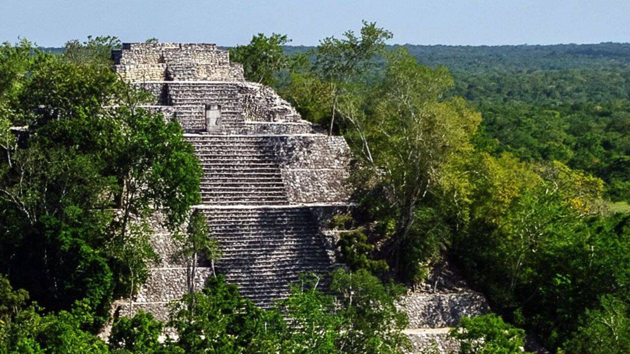
A massive ancient Maya city lay hidden for centuries beneath the dense canopy of Campeche, Mexico, only to be found because a graduate student scrolled to the second page of a Google search.
In 2024, Luke Auld-Thomas, a PhD candidate at Tulane University, processed a publicly available 2013 airborne laser scanning survey originally commissioned for environmental monitoring. The data revealed Valeriana, a sprawling metropolis containing pyramids, sports fields, causeways connecting neighborhoods, and amphitheaters. It is the second densest Maya site ever found, surpassed only by Calakmul. This discovery did not require a machete-wielding expedition or millions of dollars in fresh funding. It required looking at old data through an archaeological lens, exposing a critical gap in how governments and scientific institutions manage planetary data.
The revelation points to a frustrating truth. We are not limited by our technology, but by our bureaucratic silos.
The Accidental Discovery of Valeriana
Archaeology has traditionally relied on foot surveys. Scientists walked miles through thick brush, mapping structures one painstaking yard at a time. This method is slow. It takes decades to map a fraction of a regional system.
The advent of Light Detection and Ranging, known as LiDAR, fundamentally altered this dynamic. By firing hundreds of thousands of laser pulses per second from an airplane, researchers can map the ground topography beneath dense vegetation. The sensor measures the time it takes for the light pulses to bounce back, creating a three-dimensional map of the terrain. When processed with specific filters, it strips away the trees to reveal the human modifications underneath.
When the Mexican consortium Chicbul funded a LiDAR survey in 2013, their goal was modern environmental assessment. They wanted to measure carbon storage and monitor forest degradation. They had no interest in ancient ruins. The data was published online, where it sat unused by archaeologists for over a decade.
Auld-Thomas happened to analyze the data using algorithms tuned for archaeological features. The results were immediate. Valeriana was not a small settlement or a simple outpost. The site covers over sixteen square kilometers and features two major architectural hubs. It sits just fifteen minutes away from a major highway near Xpujil, an area currently populated by modern farmers who had been walking over the ruins for generations without realizing the true scale of the urban center beneath their feet.
The survey revealed 6,764 distinct structures. The density is staggering, comparable to the major urban centers of Tikal and Copan. The discovery challenges the long-held assumption that the Maya lowlands were sparsely populated rural areas outside of the known mega-cities.
The Silo Problem in Modern Science
Valeriana is a triumph of individual initiative, but it represents a systemic failure of institutional collaboration. Government agencies, environmental groups, and infrastructure developers collect petabytes of remote sensing data every year. Most of this information remains locked in proprietary databases or buried on obscure public servers.
Data is expensive to collect. Flying a plane equipped with a high-grade LiDAR system costs tens of thousands of dollars per day. Because these flights are funded by specific grants with narrow objectives, the data is rarely cross-referenced across different scientific disciplines. An environmental agency checks the tree canopy and archives the file. A forestry department measures biomass and shelves the drive.
Meanwhile, archaeologists struggle to secure the funding necessary to commission their own flights.
+-------------------------------------------------------------------+
|                  THE LIIDAR DATA SQUANDERING CYCLE                 |
+-------------------------------------------------------------------+
|  1. High-cost public or corporate funding for specific project    |
|  2. Single-use analysis (e.g., forestry, pipeline planning)       |
|  3. Data archived in isolated, non-indexed databases              |
|  4. Academic researchers remain unaware of existing data existence|
|  5. Redundant funding requested or historical sites overlooked    |
+-------------------------------------------------------------------+
This structural isolation creates massive inefficiencies. The Mexican government, like many others, requires environmental impact assessments for major infrastructure projects, such as the construction of the Tren Maya railway. These assessments generate immense amounts of geographical data. Yet, the mechanism to seamlessly transfer these datasets to institutions like the National Institute of Anthropology and History is often bogged down by legal red tape, intellectual property concerns, and plain administrative inertia.
The cost of this inertia is high. While Valeriana was found intact, other undocumented sites are regularly destroyed by agricultural expansion, urban sprawl, and infrastructure development before scientists ever learn they exist.
The Myth of the Virgin Jungle
The discovery of Valeriana shatters the persistent romantic myth of the pristine, untouched jungle. For over a century, popular narratives have framed Central American rainforests as wild, empty spaces where ancient people lived in small, isolated groups. The LiDAR data tells a completely different story.
The landscape was heavily engineered. The Maya did not just live in the jungle; they managed it on an industrial scale. The survey showed extensive agricultural terracing, channelized fields, and massive reservoirs designed to capture water during the severe dry seasons. The sheer volume of modification suggests a population density that required highly centralized governance and complex economic networks to survive.
This infrastructure reveals a sophisticated understanding of water management. The Maya modified entire hillsides to direct rainwater into artificial basins. This was not a primitive society at the mercy of nature, but a highly organized urban civilization that altered the topography to maximize food production.
By viewing these regions as empty wilderness, modern policy often ignores the historical reality of the land. Understanding how ancient populations managed water and agriculture in these specific ecosystems could provide vital clues for modern climate adaptation in the same regions.
The Financial Reality of Exploration
It is easy to celebrate the democratization of science when a graduate student finds a city using free data. However, relying on happy accidents is an unsustainable methodology.
Archaeological funding is in a state of perpetual crisis. Major grant-giving bodies prefer to fund high-profile, physical excavations that yield museum-quality artifacts. Funding the slow, unglamorous work of data analysis and digital curation is a much harder sell.
Auld-Thomas was able to dedicate time to analyzing the Chicbul data because his fellowship allowed him the flexibility to explore. Most researchers face intense pressure to produce immediate, publishable results from active field projects. Spending weeks parsing raw, decade-old forestry data is considered a high-risk gamble that few early-career academics can afford.
Furthermore, processing LiDAR data is not simple. It requires specialized software and significant computing power. While the raw data might be free, the expertise required to interpret it is not. Distinguishing between a natural limestone ridge and a collapsed ancient terrace requires years of training. Without institutional support to train researchers in computational archaeology, vast troves of data will remain unexamined.
The Limits of Automation
The obvious response to this data surplus is automation. Machine learning models can be trained to recognize archaeological features in LiDAR data, potentially scanning entire countries in a fraction of the time it takes a human.
This approach has serious limitations. AI models are excellent at finding standard shapes, like the perfect squares of pyramids or the straight lines of causeways. They struggle significantly with highly eroded structures, structures built from organic materials, or modifications that follow natural contours, such as agricultural terraces.
+-------------------------------------------------------------------+
|               SATELLITE DATA VS. LIIDAR CAPABILITIES               |
+-------------------------------------------------------------------+
| Feature               | Satellite Imagery   | LiDAR Scanning      |
+-----------------------+---------------------+---------------------+
| Canopy Penetration    | Poor (Top only)     | Excellent (Ground)  |
| Vertical Accuracy     | Low                 | High (Centimeters)  |
| Cost per Square KM    | Low to Moderate     | Very High           |
| Identifies Terraces   | Rarely              | Consistently        |
| Processing Time       | Fast                | Slow / Complex      |
+-----------------------+---------------------+---------------------+
In Valeriana, many of the structures were heavily degraded by centuries of erosion and tree root growth. A standard object-detection algorithm would likely miss a significant portion of the city, misidentifying ancient terraces as natural hillside variations. Human expertise remains irreplaceable for interpreting the subtle, messy realities of ancient architecture.
The solution is not to replace human analysts with machines, but to build better collaborative platforms. We need centralized, cross-disciplinary repositories where data collected by any entity—whether a logging company, an oil exploration firm, or an environmental nonprofit—is automatically flagged for potential archaeological value.
A Blueprint for Open Access Archaeology
To prevent discoveries like Valeriana from being isolated anomalies, the scientific community must demand a fundamental restructuring of geographical data management.
First, governments should mandate that any remote sensing survey funded by public money must be deposited into a central, searchable archive after a short exclusivity period. If a forestry department flies a LiDAR mission, the raw data should automatically become available to other state-funded research institutions.
Second, we must bridge the gap between commercial industries and academia. Oil, gas, mining, and timber companies possess massive amounts of high-resolution subsurface and aerial data. They often hide this data behind a wall of corporate secrecy, fearing that the discovery of cultural heritage sites will delay their operations or create legal liabilities.
A framework must be established that protects companies from punitive delays while allowing researchers to access data for regional mapping. In many jurisdictions, laws protect developers if they report a site during construction, but few incentives exist for them to share data before the bulldozers arrive.
The discovery of Valeriana proves that the history of human civilization is not lost; it is simply unread. The records are sitting on hard drives in government basements and corporate servers, waiting for someone to look at the right coordinate with the right algorithm. We do not need to wait for technology to advance to uncover the next lost empire. We just need to open the archives.