The overflow of Indonesian river systems during peak precipitation is not a freak meteorological accident but the inevitable output of a specific hydrological equation. When rainfall intensity exceeds the infiltration capacity of the soil and the volumetric capacity of the river channel, the system enters a state of hydraulic failure. In the Indonesian context, specifically across the Java and Sumatra corridors, this failure is compounded by a triad of structural stressors: rapid land-use conversion, sediment-induced channel constriction, and the physical limitations of existing drainage infrastructure.
The Volumetric Breach Framework
To understand why an Indonesian river overflows, one must look at the Discharge Equation ($Q = A \times v$), where $Q$ is discharge, $A$ is the cross-sectional area of the river, and $v$ is the velocity of the flow. Overflow occurs when the incoming volume of water from upstream runoff ($Q_{in}$) exceeds the maximum capacity of the channel ($Q_{max}$). Meanwhile, you can find similar events here: The Aluminum Giant and the Morning Bread.
The Compression of Infiltration Time
In a natural state, a significant percentage of tropical rainfall is absorbed by the soil or intercepted by canopy cover. Urbanization in regions like Jakarta, Bandung, and Semarang has replaced permeable surfaces with impervious concrete and asphalt. This transition creates a "flashy" hydrograph. Instead of a gradual rise in water levels, the river experiences a vertical spike in volume because the lag time—the interval between peak rainfall and peak discharge—has been decimated.
The Sedimentation Bottleneck
Indonesian rivers suffer from extreme sediment loads, often exacerbated by upstream deforestation and volcanic soil instability. As sediment settles on the riverbed, the effective cross-sectional area ($A$) of the channel decreases. To understand the full picture, check out the recent article by NPR.
- Bed Aggradation: The rising level of the riverbed means that even "normal" seasonal rains can reach the top of the banks.
- Roughness Coefficient: Debris and silt increase the friction of the riverbed, slowing the velocity ($v$) of the water. When velocity decreases, the height of the water must increase to maintain the same discharge rate, pushing the water level over the levees.
The Convergence of Topography and Tide
The geographic profile of Indonesia’s major urban centers introduces a secondary layer of complexity: the Backwater Effect. Most Indonesian cities are coastal or deltaic. When heavy inland rains coincide with high tides or storm surges, the river cannot discharge into the sea.
The sea essentially acts as a hydraulic wall. This creates a backwater curve where the water level rises far upstream from the actual mouth of the river. In cities like Jakarta, where land subsidence—driven by excessive groundwater extraction—has dropped the elevation of the ground by up to 25 centimeters per year in certain districts, the river surface is often physically higher than the surrounding streets. At this point, the river is no longer a drainage tool; it is a pressurized vessel held back only by concrete walls.
Anthropogenic Obstructions and Flow Resistance
Beyond the broad hydrological variables, the specific failure points in Indonesian rivers are often found in the "micro-geometry" of the urban channel.
- Encroachment of Riparian Zones: Spontaneous settlements (kampungs) often narrow the river corridor. This narrowing forces a high volume of water through a smaller "throat," increasing pressure on the banks and causing localized breaching.
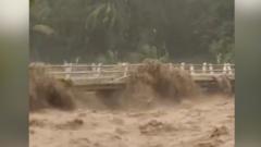
- Solid Waste Macro-Friction: The accumulation of plastic and household waste does more than pollute; it creates physical dams at bridge pylons and sluice gates. This creates a "staircase effect" in the river’s elevation profile, where water pools behind a trash-clogged bridge until it spills over the sides.
- Pump Station Latency: Many Indonesian flood mitigation systems rely on active pumping rather than passive gravity drainage. If the power grid fails during a storm or if the pumps are not maintained to handle the grit and debris in the water, the local drainage system reaches a dead-end, leading to "pluvial" flooding independent of the river's actual level.
The Failure of Vertical Mitigation
Current engineering strategies in Indonesia have leaned heavily on "normalization"—the process of straightening, deepening, and walling rivers with concrete. While this increases $v$ (velocity) and temporarily increases $A$ (area), it creates a dangerous transfer of risk.
By accelerating the water through one district, the system simply delivers a larger, more powerful volume of water to the downstream district faster than it can handle. This creates a "cascading failure" where the breach of one levee relieves pressure in one area only to inundate another with high-velocity, destructive flows. Furthermore, concrete walls prevent the natural recharging of aquifers, worsening the subsidence that makes the city vulnerable in the first place.
Operational Realities of Tropical Precipitation
Precipitation in the Indonesian archipelago is governed by the Intertropical Convergence Zone (ITCZ) and the monsoon cycles. However, the increasing frequency of "Extreme Rainfall Events" (EREs)—defined as rainfall exceeding 150mm in a 24-hour period—is testing the limits of 20th-century drainage designs.
Data suggests that the intensity of these bursts is outstripping the "Design Return Period" used by civil engineers. A drain built to handle a "once-in-50-years" storm is now being confronted by those conditions every five to ten years. This is not a failure of maintenance, but a failure of the underlying statistical assumptions used to build the infrastructure.
Strategic Pivot: From Resistance to Resilience
The existing strategy of fighting the river with higher walls has reached a point of diminishing returns. The path forward requires a shift toward Integrated Water Resources Management (IWRM), focusing on three specific interventions:
1. Upstream Retention and Spatial Decoupling
The objective must be to increase the "Lag Time" artificially. This involves the construction of "Dry Dams" and detention basins in the highlands. These structures remain empty during the dry season but capture the initial spike of a storm, releasing the water into the river system at a controlled rate that does not exceed $Q_{max}$ downstream.
2. The "Sponge City" Integration
Urban centers must be retrofitted with permeable pavements, bioswales, and "vertical rain gardens." By converting 20% of an urban area back to a semi-permeable state, the peak runoff volume can be reduced by up to 30%. This reduces the burden on the river channels and allows the existing infrastructure to function within its intended parameters.
3. Precision Dredging and Bathymetric Monitoring
Instead of reactive dredging after a flood, municipal authorities must employ continuous bathymetric scanning to identify siltation hotspots in real-time. Maintaining the design depth of the river is a more cost-effective method of flood prevention than building higher levees.
The structural reality is clear: Indonesia cannot "wall" its way out of hydrological reality. The rivers will continue to overflow as long as the rate of runoff remains decoupled from the physical capacity of the channels. The move from "river normalization" to "river naturalization"—where floodplains are restored and the river is allowed "room" to breathe—is the only viable long-term defense against the increasing volatility of tropical weather patterns. Decentralizing the water management system to prioritize local absorption over centralized discharge is the necessary evolution for the survival of Indonesia's coastal metropolises.


