Standard emergency management frameworks quantify wildfire impact almost exclusively through two metrics: hectares burned and active fire perimeters. This spatial reductionism obscures the actual operational and structural damage of modern conflagrations. When wildfires sweep across Portugal, Spain, and Greece simultaneously, the primary crisis is not merely land consumption; it is the systemic degradation of critical infrastructure, the generation of highly toxic atmospheric payloads, and the logistical saturation of transnational response networks. Evaluating these crises requires moving beyond simple geographic metrics toward a multi-variable calculation that accounts for industrial interface contamination, fuel chemistry accumulation, and international asset allocation bottlenecks.
The traditional suppression model assumes that fires are isolated containment problems. In reality, the modern fire profile in Southern Europe behaves as a compound threat system where rural land abandonment, high-velocity wind vectors, and industrial-zone proximity intersect. To understand the true operational reality of the current fires burning in regions like Vouzela, Girona, and Thessaloniki, analysts must deconstruct the mechanisms of risk accumulation and the cascading failures of standard containment strategies.
The Three Pillars of Modern Fire Velocity
The progression of contemporary wildfires across the Mediterranean basin is governed by a distinct tripartite framework of structural vulnerabilities. These variables dictate why modern fires bypass traditional containment lines and overwhelm localized suppression efforts.
Fuel Load Friction and Rural Depopulation
The fundamental cause of increased fire intensity across Portugal and Spain is the accumulation of unmanaged biomass. Over the past several decades, structural shifts in rural economies have led to extensive agricultural abandonment. Without consistent grazing, clearing, or small-scale farming, vacant plots accumulate dense layers of fine fuels and volatile ignitable flora, particularly invasive eucalyptus and unmanaged pine stands.
This creates a high-density fuel bed with low moisture retention. When a fire enters these unmanaged zones, the rate of heat release per unit of fire front length increases exponentially. Traditional hand-crews and light mechanized units cannot establish lines fast enough to match the energy output of the fuel bed.
Meteorological Velocity and Atmospheric Coupling
The second variable involves the atmospheric feedback loops generated by sustained high temperatures and low relative humidity. Under extreme fire weather conditions, large blazes cease to be passive victims of ambient wind; they become active atmospheric drivers.
When a fire front achieves sufficient energy output, it creates a powerful convective column. This column draws in surrounding air at high velocities, generating localized wind shifts that defy regional meteorological forecasts. This atmospheric coupling accelerates spotting—the mechanism where burning embers are lofted kilometers ahead of the main fire front, initiating secondary ignitions and rendering static firebreaks useless.
The Human Negligence Coefficient
Suppression organizations are structurally optimized to respond to single-point ignitions. However, data from Greek fire services indicates that roughly 85% of wildfire ignitions stem from human negligence. This includes agricultural machinery sparks, unmitigated outdoor maintenance, and improperly managed waste disposal.
The structural issue here is timing. These accidental ignitions regularly occur during peak diurnal burning periods—between 11:00 and 16:00—when temperatures are highest and fuel moisture is lowest. A single negligent spark at 13:00 creates a near-instantaneous transition from ignition to an escaped, high-intensity surface fire, bypassing the early-intervention window that fire departments rely on for high probability containment.
The Urban-Industrial Interface Bottleneck
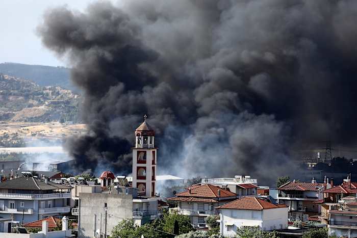
The structural vulnerability of modern fire tracking is highlighted by the recent fire on the outskirts of Thessaloniki, Greece, where a blaze transitioned from a vegetative brush fire into an industrial recycling facility ignition. This transition exposes the limitation of treating wildfires purely as environmental crises.
When a wildfire penetrates an urban-industrial interface, the risk profile shifts from resource loss to chemical contamination. Standard biomass combustion yields primary particulates like PM2.5 and PM10, alongside carbon monoxide and volatile organic compounds. However, when the fuel source shifts to processed plastics, industrial polymers, and heavy vehicles inside a recycling plant, the chemical composition of the smoke column changes completely.
[Vegetative Wildfire Front]
       │
       ▼ (Wind Vector Over-Run)
[Industrial Interface Breach]
       │
       ▼ (Polymer & Chemical Combustion)
[Toxic Atmospheric Payload] ──► [Urban Inversion & Severe Respiratory Risk]
Industrial facility fires introduce highly hazardous compounds into the atmosphere, including:
- Hydrogen Cyanide (HCN): A potent asphyxiant that interferes with cellular respiration.
- Dioxins and Furans: Highly toxic, persistent organic pollutants generated during the incomplete combustion of chlorinated plastics.
- Heavy Metal Particulates: Suspended particles of lead, cadmium, and antimony derived from industrial components and electronics.
This creates an immediate operational bottleneck. Standard wildfire smoke management advises local populations to shelter in place or evacuate based on visibility and general air quality indices. Industrial smoke payloads require specialized hazardous materials (HAZMAT) assessment and long-range atmospheric dispersion modeling.
The presence of toxic smoke forces authorities to mandate strict indoor confinement across dense urban zones, such as parts of Thessaloniki, shutting down commercial activities and overwhelming local public health systems. The economic and medical impact of this toxic payload often exceeds the direct financial damage caused by the physical destruction of the manufacturing or recycling facility itself.
Quantifying the Suppressive Asset Satiation Point
To understand why international deployments are required—such as Spain and Italy sending aircraft and personnel to reinforce Portuguese crews in the Vouzela region—analysts must look at the mathematical limits of suppression capacity. Every fire department operates under a strict suppression asset satiation point, defined as the moment when the total energy output and perimeter growth rate of active fires exceed the cumulative suppression capacity of available crews and machinery.
Consider the operational reality in central Portugal, where a single blaze consumed roughly 12,000 hectares over a three-day period. Managing a fire of this magnitude requires continuous, simultaneous operations: establishing containment perimeters, conducting defensive burning, protecting structures, and managing supply lines.
The limitation of aerial suppression highlights this bottleneck. While water-dropping planes and helicopters are vital for reducing fire intensity and cooling hotspots, they cannot stop a fire on their own. Aerial assets are strictly bound by operational constraints:
- Diurnal Windows: Fixed-wing and rotary aircraft cannot fly firefighting missions during nocturnal periods due to severe terrain collision risks and low visibility.
- Turnaround Inefficiencies: The utility of an aircraft drops sharply if the water source or retardant reload station is distant from the active front. Long flight legs mean fewer drops per hour, allowing the fire front to recover its thermal momentum between drops.
- Turbulence and Visibility Caps: Extreme convection columns and dense smoke layers frequently ground aircraft due to zero-visibility conditions and severe, unpredictable downdrafts.
When these limitations are met, the ground crews—numbering over 1,200 in the Vouzela deployment—must hold the lines manually. When multiple high-intensity fires break out across a continent simultaneously, the European civil protection framework faces a resource allocation dilemma. Deploying assets from Italy or Spain to Portugal temporarily reduces the domestic reserve margin of those donor nations. If a major wind shift or ignition event occurs in Spain while its crews are deployed abroad, the domestic suppression network can hit its own satiation point far more rapidly, turning localized incidents into uncontained regional disasters.
Architectural Vulnerabilities in Fire Detection Frameworks
The deployment of low-orbit satellite constellations by countries like Greece underscores a critical technological transition. Historical tracking relied heavily on ground-based watchtowers and opportunistic civilian reporting. This methodology carries a substantial discovery lag, frequently allowing fires to escape initial attack phases before resources are dispatched.
Satellite monitoring systems mitigate this lag but present their own structural limits:
- Cloud and Smoke Occlusion: Optical satellite sensors cannot penetrate thick cloud cover or dense smoke layers. A fire that generates a massive, low-lying smoke canopy can effectively hide its own perimeter growth from space-based visual mapping tools.
- Revisit Rate Latency: While geostationary satellites offer continuous coverage, their spatial resolution is often too coarse to detect small, early-stage ignitions. Conversely, high-resolution polar-orbiting satellites provide exceptional detail but only pass over a specific coordinate a few times a day, creating an information gap between passes.
- Thermal Anomaly False Positives: Automated thermal alerts can be triggered by legitimate industrial heat signatures, agricultural operations, or highly reflective surfaces, requiring manual verification protocols that add minutes to response dispatch pipelines.
The Long-Term Operational Playbook
Mitigating the escalating fire regimes of Southern Europe requires shifting from a policy of reactive suppression to a model of proactive structural disruption. Continuing to rely entirely on increasing the volume of firefighters and water-dropping aircraft is an unsustainable strategy that fails to address the underlying causes of fire velocity.
The primary strategic action must focus on landscape-scale fuel modification. Governments must mandate and fund the creation of strategic fuel breaks and the reintroduction of prescribed burning programs during low-risk winter windows. This process reduces the continuous fuel connectivity across vacant and abandoned rural lands, lowering the maximum potential energy output of future ignitions so they remain within the suppression capabilities of standard ground forces.
Furthermore, urban planning and zoning laws must adapt to the realities of the industrial interface. Industrial facilities, particularly those processing volatile or recyclable materials, must be subject to strict defensible space mandates. This involves establishing clear, non-combustible buffer zones between wildland vegetation and commercial structures, alongside the installation of dedicated, high-volume automated foam or water drenching systems along facility perimeters. Only by decoupling industrial assets from wildland fuel vectors can cities prevent localized vegetative blazes from transforming into regional toxic events.