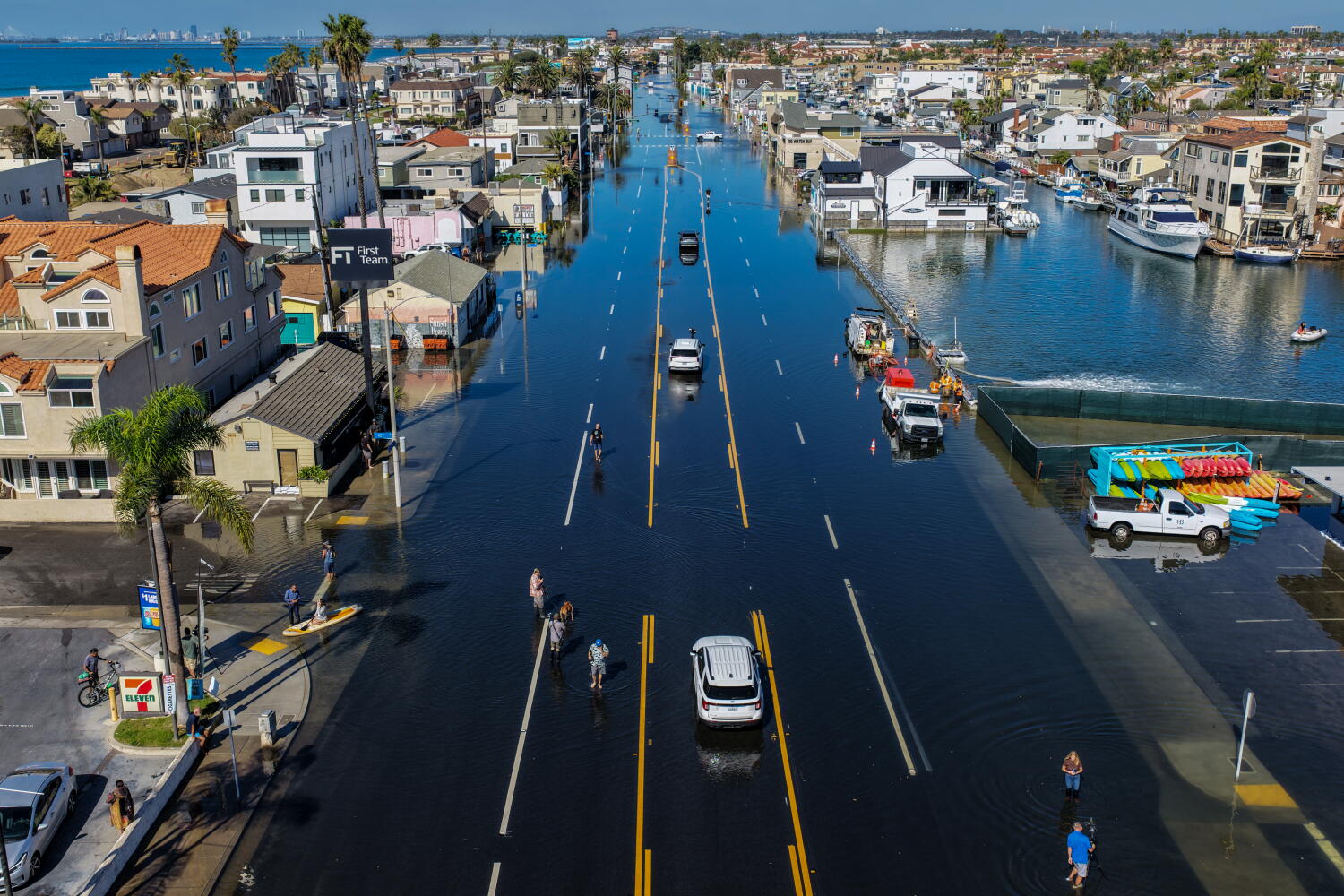
Southern California is flooding because king tides, El Niño thermal expansion, and decades-old coastal engineering are colliding at the exact same moment. When a strong El Niño warms the eastern Pacific, the water physically expands and pushes sea levels higher along the California coast for months at a time. Stack a seasonal king tide—the highest astronomical tide of the year—on top of that elevated baseline, and low-lying communities from Imperial Beach to Santa Barbara go underwater even on sunny, cloudless days.
Local news reports love dramatic footage of waves crashing over the Newport Beach boardwalk or water pooling in Seal Beach alleys. They treat these events like freak weather anomalies. They are not. What residents are watching is a preview of baseline daily conditions within the next two decades, exposed by a coastal defense system built for a climate that no longer exists.
The Physics Behind the Surge
Most coverage stops at the phrase "high tides" without explaining why the ocean is suddenly several inches taller than usual. Three distinct physical mechanisms stack together during a major coastal flood event in Southern California.
First comes astronomical alignment. King tides occur when the Earth, moon, and sun align at perigee—the point where the moon is closest to Earth in its elliptical orbit. This gravitational pull creates extreme tidal ranges, pulling water sharply away from the shore at low tide and pushing it dangerously high at high tide.
Second is thermal expansion driven by El Niño. During an El Niño cycle, trade winds weaken across the equatorial Pacific, allowing warm water from the western Pacific to slosh eastward toward the Americas. Water expands as it warms. Along the Southern California bight, this prolonged warming raises local sea surface heights by four to eight inches over an entire winter season. That extra half-foot of water acts as a launchpad.
Third is atmospheric pressure and storm surge. When low-pressure winter storms drop down from the Gulf of Alaska, the drop in barometric pressure literally allows the ocean surface to bulge upward. Combine that bulge with wind-driven swell from the west or southwest, and you get water overtopping seawalls that held firm for half a century.
The Illusion of the Seawall
Walk along the coast in Del Mar, Laguna Beach, or Malibu, and you will see millions of dollars of private and municipal armor. Concrete seawalls. Riprap boulder piles. Wooden bulkheads. Homeowners spend fortunes installing them to protect oceanfront real estate, operating under the assumption that hard barriers stop the ocean.
They do not. Seawalls merely redirect energy.
When a massive swell hits a vertical concrete wall during a record high tide, the wave energy has nowhere to go except down and sideways. That downward force scours the sand directly in front of the wall, deepening the water at the base of the structure. Deeper water allows larger waves to reach the wall without breaking offshore first, which accelerates erosion on neighboring unprotected properties and eventually undermines the wall itself.
Consider a hypothetical example of a coastal cul-de-sac protected by a 1970s-era concrete bulkhead. During a standard high tide, waves break fifty yards offshore, dissipating their energy across a wide, sloping sandy beach. During a king tide boosted by El Niño sea levels, the water reaches the base of the wall before breaking. The wave slams directly into the concrete, shoots vertical spray thirty feet into the air, and floods the street behind it. Worse, the backwash strips away the remaining beach sand, ensuring that even normal tides will reach the wall next month.
Coastal engineers call this coastal squeeze. As sea levels rise against a fixed hard barrier, the beach simply disappears. Without a wide sandy beach to act as a natural shock absorber, Southern California's multi-billion-dollar coastline loses its primary line of defense.
The Invisible Threat From Below
While television cameras focus on waves crashing over Pacific Coast Highway, civil engineers worry about something far less photogenic: groundwater inundation.
Coastal aquifers sit right beneath the surface of low-lying beach cities like Venice, Huntington Beach, and Coronado. These underground freshwater layers float on top of denser saltwater pushing in from the Pacific. As ocean levels rise during prolonged El Niño events, that saltwater wedge pushes inland, forcing the freshwater table upward toward the surface.
Long before ocean waves ever breach a seawall, rising groundwater begins flooding subterranean infrastructure from the bottom up.
- Storm drains fail: Municipal drainage systems rely on gravity to empty rainwater into the ocean. When high tides submerge outfall pipes, seawater backs up into the drains. If it rains during a king tide, street runoff has nowhere to go, flooding neighborhoods blocks away from the sand.
- Sewer lines corrode: Saltwater infiltration into aging clay and concrete sewer pipes degrades infrastructure, increases treatment plant loads, and triggers raw sewage spills into coastal estuaries.
- Foundations and utilities flood: Underground parking garages, electrical vaults, and utility corridors begin taking on water through concrete cracks, causing localized blackouts and structural decay.
You cannot build a seawall against rising groundwater. Pumping it out only draws more saltwater inland, contaminating municipal water supplies and causing the land itself to subside.
The Economics of Coastal Denial
The real story behind Southern California's flooding is not meteorological; it is financial. The state's coastal economy generates tens of billions of dollars annually through tourism, ports, and real estate taxes. Yet the financial mechanisms governing coastal risk remain completely detached from physical reality.
For decades, federal flood insurance programs and municipal zoning boards subsidized development in high-risk zones. Homeowners rebuilt damaged structures in the exact same footprint after every major El Niño winter—1983, 1998, 2016—treating predictable cyclical devastation as an act of God.
That math is breaking down.
Private insurers have already begun retreating from California's fire-prone wildland-urban interface. The exact same actuarial reckoning is moving toward the coast. As flood models incorporate compounding tidal anomalies and chronic groundwater intrusion, property insurance premiums in low-lying coastal zip codes are climbing sharply, while coverage caps shrink.
Municipalities face an even sharper bind. Local governments rely heavily on property tax revenue from ultra-high-value oceanfront parcels. If a city like Del Mar or Imperial Beach admits that certain neighborhoods cannot be saved, property values drop, taking municipal tax bases with them. Conversely, trying to save those neighborhoods through continuous beach nourishment—dredging offshore sand and pumping it onto eroding shores—costs tens of millions of dollars every few years. During a single severe El Niño winter, high-energy swells can strip away a $15 million sand replenishment project in forty-eight hours.
Why Managed Retreat Remains Political Poison
In policy circles, the term managed retreat refers to the strategic relocation of roads, utilities, and buildings away from eroding shorelines, allowing natural beaches and wetlands to migrate inland. Ecologically and financially, it is often the only viable long-term option.
Politically, it is dead on arrival.
Take the LOSSAN rail corridor in San Clemente and Del Mar. This single track is the only coastal rail link connecting San Diego to Los Angeles, carrying both commuter trains and critical military and commercial freight. Sections of the track run along eroding coastal bluffs and narrow beach strips. Every time heavy winter swells and high tides undercut the bluffs or wash over the tracks, rail service shuts down for weeks or months while crews dump thousands of tons of boulders onto the beach to stabilize the railbed.
Moving that rail line inland requires tunneling through coastal mountains at an estimated cost of several billion dollars and a timeline stretching over a decade. Leaving it where it is guarantees repeated shutdowns and escalating emergency repair bills every time the Pacific warms up. Neither option is painless, yet political leaders routinely choose short-term emergency armoring because no one wants to take responsibility for the price tag or disruption of permanent relocation.
The same paralysis grips residential zoning. The California Coastal Commission has increasingly pushed for stricter rules on new seawalls, arguing correctly that private armoring destroys public beaches. Homeowners sue, arguing that denying them the right to protect their property constitutes an unconstitutional taking under the Fifth Amendment. While those lawsuits wind through appellate courts for years, the ocean keeps rising.
What Actually Works Against Compound Flooding
If hard armor fails over time and full retreat faces decades of legal gridlock, coastal planners are left with a narrow set of practical interventions that buy time without destroying the shoreline.
Living shorelines replace vertical concrete with sloped, vegetated dunes and cobble berms. By mimicking natural coastal geography, cobble berms absorb wave energy gradually rather than reflecting it violently. Native dune grasses trap windblown sand, allowing the barrier to grow and self-repair between storm cycles. Ventura County's Surfers' Point project demonstrated that pulling a parking lot back just sixty feet and installing a cobble-and-dune system could withstand severe winter swells that previously destroyed asphalt and infrastructure.
Tidal valves and pressurized drainage address the backdoor flooding problem. Installing one-way duckbill check valves on storm drain outfalls prevents high tides from surging backward into city streets, while pump stations force rainwater out against high ocean levels. These upgrades do not stop ocean overtopping, but they prevent minor coastal flooding from turning into inland neighborhood lakes during winter rainstorms.
Rolling easements offer a legal middle ground between immediate buyouts and endless armoring. Under a rolling easement, property owners can continue using their oceanfront homes as long as the land remains dry, with the explicit legal agreement that once the mean high tide line reaches the structure, the building must be removed and no seawall can be built. It shifts long-term risk back onto the property owner without requiring immediate taxpayer buyouts.
The New Baseline
Look closely at the water lines left on seawalls and bridge pilings after this winter's record tides recede. Those salt stains mark the exact elevation where normal daily high tides will sit within a generation.
El Niño does not create a temporary freak event; it simply pulls the future forward by twenty years for a single winter. Every flooded intersection in Seal Beach, every washed-out railbed in San Clemente, and every backed-up storm drain in Mission Beach is a live stress test of Southern California's coastal infrastructure. Right now, the infrastructure is failing the test, and continuing to pour concrete onto eroding sand will not change the grade.