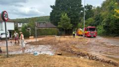
Every time a quarry wall gives way or a pit fills up and spills over into residential streets, the mainstream media rolls out the exact same tired script. Homes flooded. Residents evacuated. Emergency services heroes stepping in. The town council expresses profound shock.
Cut to footage of muddy water lapping against suburban garage doors. Recently making news lately: Why The Panic Over Regional Sprawls Misses The Cold Logic Governing Middle East Escalation.
It is a convenient narrative. Mother Nature struck again. A freak act of hydrological rebellion.
It is also complete garbage. Further insights regarding the matter are covered by The New York Times.
I have spent two decades walking industrial sites, reviewing geotechnical surveys, and watching municipalities approve permits for housing developments built directly adjacent to active and abandoned mineral extraction zones. The sudden flooding of nearby neighborhoods is never an unpredictable tragedy. It is the entirely mathematical result of human denial, terrible municipal planning, and the willful blindness of developers who treat water tables like suggestion boxes.
Let us stop pretending these incidents are natural disasters. They are engineering failures compounded by real estate greed.
The Lazy Consensus of the Freak Accident
The public narrative relies on a comfortable delusion. People want to believe that the ground beneath our feet is a permanent, static floor. When an old limestone quarry or sand pit suddenly breaches its banks or experiences a sidewall collapse, sending millions of gallons of slurry into adjacent backyards, the automatic reflex is to point fingers at excessive rainfall or groundwater shifts.
This ignores the basic mechanics of how excavation alters hydrology.
When you dig a massive hole seventy feet below the regional water table, you are not just extracting aggregate. You are creating a permanent artificial sump. For years, active extraction operations pump that water out continuously just to keep the pit dry. The surrounding soil dries out, foundations settle, and people build patios and drivehouses under the false security of an artificially lowered water table.
Then the quarry operations wind down. The pumps shut off.
Physics does not care about your zoning board approval. The water returns to its natural equilibrium level. It fills the void. And when the walls of that pit—often cut too steep, left unreinforced, or compromised by decades of heavy blasting—finally shear off under hydrostatic pressure, the surge has to go somewhere.
It goes into the basements of the subdivision built right on the historical flood fringe.
The Permitting Scam No One Talks About
How do housing developments end up kissing the property line of industrial gravel pits in the first place?
The answer lies in a cozy alliance between local tax revenues and developer lobbying. Municipalities love greenfield development. New homes mean property tax windfalls. Industrial operators love selling off depleted buffer zones for residential conversion because reclamation costs millions.
So what happens? Environmental impact assessments get sliced, diced, and minimized.
I have seen reports where hydrogeologists model worst-case rainfall scenarios using fifty-year-old climate data, completely ignoring the intensity of modern weather patterns and the reality of surrounding impervious surfaces. Asphalt and concrete do not absorb water; they accelerate runoff directly toward the lowest point in the topography. Which is, more often than not, the abandoned quarry bowl or the ditch connecting it to the municipal storm sewer.
When residents scream that they were never warned, they are telling the truth. They were sold a lifestyle of quiet cul-de-sacs and scenic views, conveniently omitting the fact that their backyard fence is perched on the lip of an unengineered retention basin.
The Brutal Physics of Quarry Failures
Let us look at what actually happens during a structural failure at a quarry site.
When a highwall fails, it is rarely a slow, polite seep. It is a rapid mass movement of saturated overburden and fractured rock.
- Hydrostatic Pressure Buildup: As water fills an abandoned pit, pressure increases exponentially against the lower sections of the rock face.
- Saturated Shear Failure: If the clay layers or fracture planes within the rock dip outward toward the residential side, the friction holding the wall in place vanishes.
- Displacement Surge: A massive volume of earth enters the water instantaneously, creating a localized displacement wave that breaches berms designed only for normal runoff.
Municipalities respond by installing temporary sandbags and pumping water back into the system. It is like putting a band-aid on an arterial bleed. The underlying vulnerability remains. If the highwall is unstable, the next heavy rain cycle will trigger the exact same cascade.
What Real Mitigation Looks Like
If we want to stop evacuating neighborhoods every time the weather turns, we have to abandon the fantasy that we can build right up to the edge of heavy industrial excavations without consequence.
First, mandatory buffer zones need to be tripled. If a developer wants to build within a kilometer of an active or dormant quarry, the burden of proof for long-term hydrogeological stability should rest entirely on them, backed by ironclad financial bonds that do not expire when the last house sells.
Second, we need to stop treating mine reclamation as an afterthought. Filling a hole with water and calling it a "lakefront community" without rigorous slope stabilization and controlled outflow engineering is an invitation for disaster.
The next time you see footage of residents bailing muddy water out of their living rooms near a pit operation, remember what you are actually looking at. It is not an act of God. It is the bill coming due for decades of bad math and willful ignorance.