Salt sits on the tongue before the rain even starts.
Anyone who has spent enough mornings near warm tropical water knows that strange, metallic hush that arrives hours ahead of a spinning cyclone. Birds vanish from the mangroves or the ironwood branches. The air feels thick enough to chew, carrying a faint scent of crushed leaves and deep-water brine. On a weather map, a hurricane and a typhoon look like twin pinwheels drawn by a restless hand. On the ground, or in a wooden boat bobbing over a rising swell, those pinwheels mean shuttered windows, generators humming in humid yards, and neighbors counting cans of beans while staring at gray horizon lines.
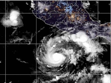
Right now, two separate tropical systems are commanding attention across opposite sides of the Pacific basin: Hurricane Trudy moving toward Mexico, and Typhoon Champi bearing down on Guam. Headlines love to treat storms like sports scores—wind speed here, millibars there, cone of uncertainty plotted in neat orange lines. Yet numbers rarely tell you what it feels like when power goes out at 2 a.m. and a palm frond slams against a corrugated roof like a shotgun blast.
I have stood on coastal porches watching palms bend until their crowns nearly brushed wet grass, feeling that low hum in my ribs when barometric pressure drops and the atmosphere turns heavy. Meteorology is a science of fluid dynamics, sea surface temperatures, and wind shear, and it is also a deeply human reckoning with vulnerability. Even seasoned forecasters admit that tropical cyclones can surprise us—sometimes wobbling north or south by a few dozen miles, sometimes intensifying faster than models anticipate when warm ocean water feeds a tight core.
How Two Storms Share the Same Breath
When people hear "hurricane" and "typhoon," they sometimes assume they are watching two completely different kinds of weather. In truth, they are the same meteorological phenomenon—a tropical cyclone—given different regional names depending on where it spins. In the Atlantic and eastern/central North Pacific, including systems threatening Mexico, we call them hurricanes. In the western North Pacific, where Guam sits in the Mariana Islands, intense tropical cyclones are called typhoons.
To make the physics intuitive, picture a giant heat engine fueled by warm ocean water and moisture rising from the sea. As warm air rises, it cools and condenses, releasing latent heat that drives air inward toward the low-pressure center, while Earth's rotation sets the whole system spinning. Think of it like water spiraling toward a drain, scaled up to hundreds of miles across and fed by an endless boiler of warm water.
What separates a tropical depression, a tropical storm, and a hurricane or typhoon is sustained wind speed, alongside the broader hazards of heavy rain, rough surf, and storm surge. A storm does not have to make a direct bullseye hit to ruin a week or flood a low-lying road. Outer rain bands can drench hillsides miles from the center, turning dry arroyos or drainage ditches into rushing torrents within hours.
A brief comparison helps clarify why two storms on opposite sides of the ocean can feel so different to the communities waiting for them:
| Feature | Hurricane Trudy (Approaching Mexico) | Typhoon Champi (Threatening Guam) |
|---|---|---|
| Ocean Basin | Eastern / Central North Pacific | Western North Pacific |
| Primary Threat Zones | Pacific coastline, mountain slopes, river valleys | Island shorelines, reefs, low-lying roads, power grid |
| Key Hazards | Heavy rainfall, flash flooding, mudslides, rough surf | Damaging gusts, pounding surf, power outages, squalls |
| Local Prep Focus | Drainage, flood-prone routes, travel adjustments | Shutters/tie-downs, water/fuel reserves, shelter readiness |
Along the Pacific Coast Toward Mexico
Let us sketch a hypothetical scenario—purely illustrative, not a report of a specific household—to ground what a storm moving toward Mexico looks like in daily life. Picture Elena, who runs a small family kitchen a few blocks back from a Pacific beach town. By mid-afternoon, the ocean swell has changed rhythm: sets arrive closer together, pushing darker water higher up the sand than they did two days ago. Elena spends an hour moving outdoor chairs under cover, taping nothing because tape on glass does little against real wind pressure, and checking that flashlights have fresh batteries.
Along Mexico's Pacific coast, geography shapes the danger just as much as wind speed. Mountains and coastal ranges rise relatively close to the shore in many stretches. When moisture-laden bands from a hurricane push inland against elevated terrain, air is forced upward, cooling rapidly and wringing out heavy rain. That rain is often the quietest killer in tropical systems—not dramatic like a crashing wave, yet capable of swelling rivers, flooding streets, and triggering mudslides on saturated slopes long after the strongest gusts pass.
Coastal travelers and local residents face a familiar dilemma when a storm approaches: do you leave early, wait for the next advisory, or ride it out? Every forecast update brings revised track details and wind radii, and waiting for certainty can mean driving through worsening rain or losing flight connections. Checking official advisories from Mexico's national meteorological service alongside international centers like the National Hurricane Center gives a clearer picture than relying on social media rumors or sensationalized maps.
A Small Island Under a Wide Sky
Now shift thousands of miles west across the Pacific to Guam. Living on an island during typhoon season changes how you read the sky. There is no driving inland to escape a storm; the ocean surrounds you on every side, and a system like Typhoon Champi tests infrastructure, supply lines, and nerves all at once.
Imagine a hypothetical resident—let's call him Tomas—living in a concrete home in central Guam. Concrete holds up far better than wood in strong gusts, yet a typhoon still demands respect. Flying debris, downed branches, salt spray coating power lines, and sudden squalls can knock out electricity even when a storm stays offshore or brushes past. Tomas fills extra jugs of tap water early, charges every power bank, clears loose items from the yard, and checks on an elderly neighbor who lives alone.
Guam's communities are accustomed to tropical cyclones, which is a blessing and a trap. Familiarity breeds steady routines—people know where to buy batteries and how to lash down tarps—yet routine can also breed complacency if a storm looks manageable on an early map. Waves driven across coral reefs and rocky shores can turn calm coves into churning whitewater, creating dangerous rip currents and coastal inundation well ahead of the core.
Why Forecast Cones Confuse Almost Everyone
Look at a standard storm map and you will usually see a line with a shaded cone stretching ahead of it. Many people assume that cone shows the size of the storm or guarantees where wind and rain will hit. It doesn't. That cone represents the probable path of the storm's center based on historical forecast errors over a given timeframe.
Dangerous winds, torrential rain, and life-threatening surf frequently extend far outside that center line. A storm can pass tens of miles away and still bring tropical-storm-force gusts, drenching downpours, and hazardous seas. Conversely, if a system shifts slightly or changes speed, impacts can arrive earlier or later than someone who only looked at a single dot on a map expected.
Uncertainty is part of weather forecasting because the atmosphere is chaotic. Tiny differences in temperature, humidity, or steering winds at one altitude can nudge a storm's track or pace. Admitting that uncertainty isn't a sign of weak science; it is the honest foundation of good preparation. When you prepare for a window of time and a broader zone of impact rather than a single pinpoint moment, a slight wobble in the forecast stops feeling like a rug pull.
Preparation That Actually Holds Up When the Lights Flicker
When a hurricane or typhoon is on the way, panic buys paper towels and bottled water while forgetting the basics that keep a household calm and safe. You do not need a bunker to be ready. You need practical habits that respect how storms actually disrupt everyday life.
Start with information and movement:
- Monitor official local and regional weather advisories rather than unverified viral posts.
- Know which roads near you flood easily during heavy rain so you aren't caught stalling out in rising water.
- Keep your vehicle fueled and your phone charged before squalls start rolling through.
Then focus on home, water, and health:
- Store enough drinking water and non-perishable food for at least several days, plus manual can openers and any needed medications.
- Secure loose outdoor items—patio furniture, potted plants, tools, trash bins—that high winds can turn into projectiles.
- Have flashlights or headlamps ready, and avoid using candles unattended or running portable generators indoors or in enclosed garages where carbon monoxide can build silently.
After the wind dies down and skies brighten, the most dangerous hours often arrive. Flooded roads hide washed-out pavement or downed wires. Fallen branches and slick surfaces turn simple cleanup into injury traps if you rush outside barefoot or climb ladders before conditions stabilize. Patience after a storm passes saves more lives than bravado during the blow.
Out on the open water, waves keep rolling long after the wind eases, carrying energy across hundreds of miles of sea. A storm is never just a line on a chart or a number in a headline; it is wind in the trees, water finding every low spot, and ordinary people deciding to look out for one another until the sky clears.